Now in its 17th year, the ESRI Petroleum User Group is quite a phenomenon. BP’s Charles Fried, PUG chairman, announced a record registration of 1,300 individuals from 350 organizations and 28 countries. The PUG’s active working groups, on 3D, metadata, geodetics and more feed into the PUG ‘LIST’ which has now expanded to a full day session.
Dangermond
ESRI founder and President Jack Dangermond spoke of the ‘openness’ of knowledge sharing through geographical information systems (GIS). GIS impacts every facet of the petroleum business, from E&P to environment, facilities. GIS is emerging as a core IT system in oil and gas moving from desktop to department and the enterprise. For Dangermond, GIS’ ‘business model’ of the world is ‘our best shot at integrated knowledge.’ GIS provides an ‘intuitive and analytical framework’ that defines interconnections between things leading to ‘oh now I understand’ moments. ESRI is moving towards services-oriented architecture (SOA). SOA fits the GIS data delivery paradigm with a multiplicity of publishers and shared interconnections.
Google Earth
Google Earth has opened the worlds’ eyes to the possibilities of GIS. Individuals are now authors and consumers, sharing knowledge with a whole new world of users thanks to SOA. In oil and gas, land, upstream, and other departments will all be able to leverage each others’ data thanks to the GIS. The IT stack is ‘evolving nicely’ and web services XML, SOAP are gaining acceptance. The move to a SOA is the ‘icing on the GIS cake.’ ESRI has worked hard on openness and interoperates with Autocad and Google Earth. Dangermond remarked, ‘As Google opens their content and I’m sure they will, you’ll be able to access more of their content from within ArcGIS.’
ArcGIS 9.2
ESRI’s latest 9.2 ArcGIS release adds several functionalities that originated as PUG List requests. 3D contouring has been enhanced with management of triangulated irregular networks (TIN) surfaces of elevation data. Image and raster capabilities have been improved with the new ArcGIS Image Server. A new ArcGIS relational schema offers better integration with data stored in Oracle—allowing for direct SQL access (as opposed to SDE). New API functionality lets developers blend ESRI, CAD and other data formats. The new technology platform is set to ‘do for enterprise what Google Earth has done for consumers.’
ArcGIS Explorer
ArcGIS Explorer a.k.a. ‘GIS for everyone’ is a ‘free’ Google Earth-like client. The ‘globe’ interface and ‘swipe’ tool comparator were used to good effect in a variety of oil-related demos including the geoprocessing of a real time weather data feed to plot a plume of fumes from a fire.
ArcGIS Online
But the star announcement was ArcGIS online, ESRI’s answer to the server side of Google Earth, to be released this month along with a high resolution set of US imagery. There will be a fee for some usage types but it will be ‘unbelievably cheap.’ A deal with PenWell adds pipeline data to the mix and the inclusion of National Geographic data was mentioned. Layers can be imported and saved to the desktop. And in a ‘couple of mouse clicks’ you have a map (applause).
BP America
Keith Everill traced BP’s history of GIS. BP started with ArcInfo in 1989, but has struggled to promote use beyond specialists and small, unsupported communities. GIS take-up has been handicapped by multiple toolsets and deployment by discrete business units, leading to duplication and little data sharing. BP successfully deployed a single version of Microsoft Office, but there is no similar ‘common operating environment’ for GIS.
GIS Appraise
This changed when a BP senior manager saw the GIS light and initiated the ‘GIS Appraise’ project, ‘a high level strategic statement to govern and articulate the vision going forward.’ In September 2006, a study determined that BP has been ‘slow to realize the value of GIS.’ There was also a realization that putting a dollar value on the benefits of GIS ‘was no longer the driving force.’ BP is now in the final stages of specifying its solution for a ‘full business lifecycle GIS.’
Geospatial paradox
Keith Fraley (Shell) believes that the current situation regarding the consumer and corporate approaches to GIS is both paradoxical and ironic. Google Earth has heralded the dawn of ‘geospatial enlightenment’ and the recognition that geography is fun. On the heels of GE and its vector brother, Google Maps, comes the ‘mashup ,’ ad-hoc combinations of spatial data layered onto a map (e.g. www.wikimapia.org). Wikis (and GE) contrast with the ‘complex’ windows icons menu pointer (WIMP) paradigm of corporate geospatial solutions. This more specialist approach ‘inhibits mass adoption.’ Silo-oriented software solutions compound the problem. Engineering chooses Autocad, the business goes for Mapinfo and geotechnical deploys ESRI. This leads to a ‘redundant asynchronous, heterogeneous geospatial technology landscape’. Naturally, everyone wants to consolidate to their own toolset. This becomes a ‘very political and costly trek towards the enterprise geospatial paradigm.’ A general lack of understanding between GIS and the IT department compounds the problems.
SOA
The answer is the services-oriented architecture (SOA) with geospatial web services serving a ‘true enterprise geospatial infrastructure.’ Using slideware from IBM and ESRI, Frayley showed how ESRI’s latest marketing is aligned with IBM’s view of SOA ‘an awesome slide’. Arc 9.2 serves catalogs, maps etc as XML/SOAP service. Google Earth and Autocad can integrate this framework.
Punchavisuthi
One of BP’s GIS implementations was the subject of Nisha Punchavisuthi’s presentation. BP’s strategic planning and integration tool (SPIT) ‘facilitates strategic thought and enhances visualization with an integrated platform for exploration data.’ Dynamic data is served with Microsoft SharePoint. SPIT includes BP’s prospect inventory and spreadsheets for data input. These are dynamically linked to an Access database whose tables are recognized in Arc GIS. End users see a simplified map view in ArcReader with a tree-view of layers, allowing drill down to OilOnline, and other data sources.
Valtus
Mark Dumka (Talisman) and Kenyon Waugh (Valtus) described how Talisman has moved to a hosted paradigm for its spatial and image data. Data such as 1m resolution satellite imagery, infrared, Landsat 7, Canadian NTS scanned topographic maps and USGS DRG are all served from Valtus’ in a ‘one stop shop.’ One client has 1˝ petabytes of data stored with Valtus. Valtus has relationships with aerial and satellite data collectors. By using Valtus, Talisman has greatly reduced internal infrastructure requirements and is leveraging Valtus’s experience of ‘troublesome’ raster datasets. The hosted model also makes it easy to deploy new technologies for storage and delivery.
Universal GeoSystems
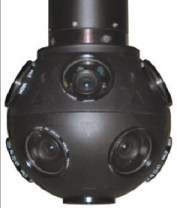
A presentation by Brett Vidican (Universal GeoSystems) showed how a nifty device, the ‘Dodeca’ video camera from Immersive Media, is transforming pipeline project management. The 11 lens camera is slung beneath a helicopter and records continually along a proposed route. After processing, the flight can be viewed as a VRML file with zoom, pan user interaction.
Immersive Media’s Dodeca Videocam
Geodetics, datums ...
No PUG would be complete without warnings about correct use of geodetic datums and transforms. While not actually a PUG presentation, we were pointed to a telling argument in favor of doing your geodetics right. This is from the USGS National Imagery and Mapping Agency, ‘When a geodetic datum is changed, coordinates of a point will usually change too. In some cases, the differences can be as large as 900 meters. Why is this important? If a soldier calling for close air support has his coordinates with respect to one datum and your coordinates are with respect to a different datum, you could fire at the targeted location and miss the requested location by hundreds of meters. The most severe consequence of your action being friendly fire!’ Now do you understand?
This article has been abstracted from an illustrated report from the PUG produced as part of The Data Room’s Technology Watch reporting service. You can now view the full text of our report from the 2005 PUG in the TechWatch section of www.oilit.com. For more on this subscription-based service please visit the Technology Watch home page or email tw@oilit.com.
© Oil IT Journal - all rights reserved.